Tom & Joyce Moomaw
1464 7th Ave South
Clinton, IA 52732
Email: tmoomaw@vzavenue.net
Memo: Report on Pike County-Mozier’s Landing, Illinois, trip. April 4-5, 1998.
Watson Cemetery, Burbridge Cemetery, Nebo, Mozier’s Landing.
April 4th: We left Clinton early in the morning and arrived in Pike County at mid-day. Did not stay long in Pittsfield, as we’d been there several times before. We drove directly to Martinsburg Township, about 4-5 miles south of Pittsfield.
I first filmed the area that I believe to be Jacob Moomaw’s (2219) farm. We had driven to this area last year with Mrs. Helen Johnson of Pittsfield, who had confirmed its location. I had also identified the location from Courthouse records in Pittsfield.
We next drove to due east to the Watson Cemetery, just across the Pittsfield-Nebo road, up on a small hillside. Jacob and Elizabeth Moomaw’s graves are in there, plus their daughter Anna (22196) and her husband Rufus Johnson. Helen’s late husband Wendell is Anna’s grandson. Helen has Jacob’s bible, which is a small leather-bound book written in German. She also had an old photo of Elizabeth (Ohmart) Moomaw.
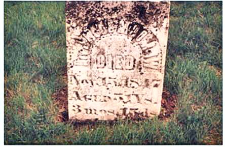
Jacob Moomaw’s
headstone in Watson Cemetery
We next drove south to Burbridge Cemetery in search of Rachel Doyle’s grave. Rachel was Adam Moomaw’s (22194) second wife, after he left California and returned to Pike County. Frank Mooma (2219481) of Chico, California descends from Adam and Rachel. Mrs. Nova Dinning of Moline, Illinois descends from Rachel and her first husband. Both have provided me with information on their family. I was unable to locate Rachel’s grave, but she is apparently in there, as is indicated by a cemetery record I found in the Pittsfield library. There were many Doyle family members in there, also indicating she is likely there. We also saw many Zumwalt headstones, which I noticed right away, because in one of Belle Toll’s letters to Aunt Marie (22194478) in 1954, she said that the Zumaltq family went with the Moomaws to California. I’m betting that this is the family. I haven’t seen any Tolls in the area, and Helen has never heard of any.
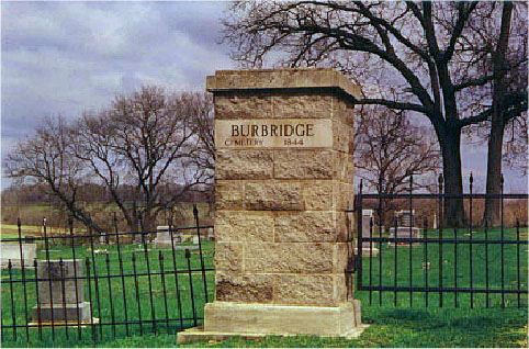
Burbridge
Cemetery
We drove south from Martinsburg along a shallow bluff to Nebo. I imagined this to be a few hours by horseback for the Moomaws in the mid 1800’s. Nebo is a small town today, with several abandoned buildings downtown. I’d thought I might stop at a local café to talk to local people, but we didn’t see one and so drove on southwest to the Mississippi.
When we reached the Mississippi River Valley, we turned south and followed the river to Mozier, Illinois. Just north of Mozier we noticed the west branch of the Panther Creek, which flows into the Mississippi. The water was very high and ran right up to the highway. At this point I couldn’t tell where the main channel of the river was, as it looked like a backwater to me. However, one certainly could pilot a boat up to Mozier. I noticed as we drove into Mozier a Bed & Breakfast with Baytown on the sign. Belle Toll had indicated in her letters to Aunt Marie that the Moomaws started their journey to California here in 1863. I couldn’t make out from her handwriting if she meant Boytown or Baytown, so now we know. At any rate, we drove through the small town before we knew it, and had to turn around. We stopped at the Mozier Shortstop, and talked to Ms. Darlene Clendening, who didn’t know where the Hard Scrable Mill was, but said she would talk to someone who may know, and she’d also ask him about the Moomaws, Tolls, etc. She subsequently has written and said that her source knew a Jim Toll years ago. We asked about Painter or Panther Creek, and she said that the West Panther Creek runs north of Mozier (which we noticed on the way in). She also explained that the main channel runs south of Mozier and we next drove down river a mile or so to take a look. Sure enough, we ran into the main channel just south of the marina.
We drove back through Mozier and drove on North to West Panther Creek. We turned up the dirt road and followed it for a short distance, maybe a quarter mile, when I noticed the water falls on the creek. I knew immediately that this was the spot, from the description Belle Toll gave in her letter (waterfalls, slate rock, etc). There was no mill or even a foundation of a mill there, but the spot fit the description. There was a cute house across the creek on a small hillside. We stopped and I talked to Mr. Bill Paquin, who owns the property. Bill is a pilot out of St. Louis who found this small-secluded hideaway that eventually he and his wife plan to retire to. He invited us over, and we had to walk across the creek on the high bridge he built so that they could get out during high water (their driveway runs right through the creek, which is no problem normally). He explained that this was the site of the gristmill, and it sat over by where his barn stands, next to the creek. The frontier people used to travel to the mill mostly by boat up or down the river, and come right up the creek to the mill for their flour, etc. He also explained that the site was a spiritual site for Native Americans, before the frontier people arrived. His wife Martha is not Indian, but he says she has a spiritual connection to Indian people and culture.
They were just into their house, and one evening while sitting on their screened porch looking at the waterfall she said she could envision and hear an Indian chanting and dancing next to the creek. They went to bed, and the next morning awoke to find that there was an Indian singing and dancing by the waterfall. He turned out to be a college professor who lives in the area, and they could not see from their porch that his students were behind the rocks while he was in prayer. He pointed out the assorted prayer ribbons that adorn the tree branches along the creek. They are left by Native Americans who come visit the site. Bill said he and his wife thoroughly enjoy their secluded home they’ve found, and recognize that it is a special place.
Unfortunately we did not take any photographs of the mill site, but quite a lot of video footage. We didn’t have time to search for anyone who may have further knowledge of the Hard Scrable Mill, so we left Panther Creek and drove to St. Charles, Missouri to spend the night before returning home the next day. We hope someday to return.
4/1/99 UPDATE
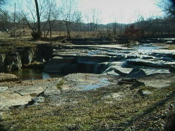
This is a photo of the waterfall site taken by the owners of the property, Bill and Martha Paquin of Alton, Illinois, on which sat the Hard Scrable Mill. The mill stood just behind where the photo was taken. Bill and Martha graciously supplied the picture.